Showing posts with label backpacking. Show all posts

Saturday, January 30, 2010

My Top 14 Favorite Hikes: Part 3 - The Final Countdown #5 to #1

part 2 is here
part 1 is here

This is the final installment of my top 14 favorite hiking and backpacking trips of all time. I am wrapping up with the top 5 and I thought I’d count them down in reverse order.

#5 Burgess Shale Hike: Kootenay, Canadian Rockies (1 day, 15 miles)


Of all the hikes on the list, this one was less of an adventure and more of a pilgrimage. The burgess shale was the first early Cambrian LagerstĂ€tten (which in an extremely fun side note is the German word for motherlode).[1] This providential[2] preservation of the soft body portions of organisms of the early Cambrian Sea provided our first window to the ‘Cambrian Explosion’. It seems to indicate[3] that only 30 million years elapsed between the development of multicellular organisms and the evolution of every major body plan that can be observed today (plus several others). But, most know the Burgess shale because of the seemingly improbable critters its consolidated, anoxic sediments record. These are critters that can decidedly cause one to ‘remember his name.’ It is also worth noting that Walcott himself and Simon Conway-Morris (the current authority on the shale) were/are both Christains.

The Burgess Shale is a world heritage site, in the Yoho National Park in the Canadian Rockies. We had to book a guided tour and were told that if we wanted to remove a rock, we were going to have to commit a body cavity to its concealment. The other hikers were, without exception, fascinating people. The most memorable one was an economics professor who studied how punctuated equilibrium could be used to predicatively model economic systems. However, while this hike might have been primarily about the history of life, it was still a fifteen mile round trip in the vastly underrated Canadian Rockies including the requisite glaciers and the trips finest waterfall. Just a thrilling day to wrap up our Glacier-Banff trip.

#4 North Lake to South Lake: King’s Canyon (4 ½ days, 55 miles)


This had to make the list simply because of its scale. It was the longest trip we have taken. It would have crept higher if we had taken longer to do it. But it is difficult to get more remote in the lower 48 than in King’s Canyon’s Evolution Valley. Hikers were scarce, passes were dramatic and the alpine meadows were pristine and unmatched. We also saw golden trout, which are famous and only life in a few lakes in the southern Sierra[4].


#3 Piegan Pass: Glacier National Park (1 day, 10 miles)

Almost everyone I know who has been to Glacier, lists it as their favorite national park, including Amanda and I. It is so startlingly original with the sharp, thin monoliths jutting wherever you turn, like the blades of an enormous gauntlet. This was our first time hiking where Grizzly’s roam and Glacier backpacking permits are notoriously hard to get so we decided to keep to longish day hikes. The whole trip was remarkable. We saw big horn sheep, mountain goats, strike-slip faults, and even a Grizzly at about 30 ft.[5] But I have never seen anything like Peigan Pass.

The soft colors and steep but rolling slopes of the landscape were offset by the stark, watchful presence of ‘the Garden Wall’. The Garden Wall competes with El Capitan as the most sublime geologic feature in the lower 48. It is a razor thin (by geologic standards), stripped[6], arĂȘte that runs through the center of the park. This is the first time I have been hiking and literally felt like I had entered a mystical parallel reality. Lakes are not supposed to be that blue. Cliffs are not supposed to be that shear. Geology is not supposed to be that mind blowingly sublime. Days are not supposed to be this full of wonder.


#2 Copper Ridge: Cascade Mountains (3 days, 25 miles)


There is a theme in the final two hikes. They are both multi-day ridge trips. Ridge hikes tend to be fantastic since you get sustained views for relatively little work (once you actually get on the ridge). We spent more time on the trail during this trip than we needed to and our packs were heavier than they had to be because Washington trails[7] are literally lined with huge blueberries in August. We would linger often to eat them and then not be hungry for meals.


Most of the trail and both campsites were well placed for extraordinary views of the Cascades[8]. The first night we looked out over the palisades range into Whatcom Pass and the second night we had great peaks to the South and our own secluded alpine lake to the North. The lake was unsurprisingly frigid, but a brief swim was still required.

A lonely Ranger manned a shelter on the highest point of copper ridge. He said that one to four groups passed through each day and was starting to get a little desperate for human contact. We also got ‘charged’ by a black bear.[9]

#1 Teton Crest Trail: Teton National Park (3 Days, 32 miles)

This was part of a 10 day Yellowstone-Teton trip[10]. The Teton hike was so spectacular; it left us feeling underwhelmed by Yellowstone. Still early in our backpacking careers, I pitched this one to Amanda by sharing that it starts with a ski lift deposits you at a starting elevation of 10,450 ft. The hike was not without elevation gain, but there was no grueling first day as is common with ridge trips. The highlights of this trip included happening on a moose[11] and cresting the ridge so close to the three stark peaks you felt like they were in reach. The loop ended at Jenny Lake where a water taxi picked us up and took us back to the parking lot.

It is hard to articulate why Teton is our favorite. But it was not even really close. Maybe it was the towering, triangular peaks. Maybe it was the lush canyons which seemed to simply be a string of one waterfall after another. Maybe it was the satisfaction of getting and staying so high and taking in so many dramatic views while skirting the pesky 4,000 foot first day. Maybe it was just 3 sweet days with my wife touching the sky and huddling under a little tarp, warming hot chocolate as the hail beat down. But the Teton Crest trail is the winner of a VERY worthy field.

______________________
[1] Since its discovery by Walcott in 1909, similar sites have been discovered in China and Greenland.
[2] Yeah, I believe that. I’m not sure who would be more offended, Fundamentalists or Atheists.
[3] Being a punk-eek (punctuated equilibrium) guy, I unsurprisingly agree with Gould in this assessment. But our guide simply would not buy this. He champions the alternate hypothesis that multicelular evolution was going on at thermal vents for millions of years before, but was just not recorded in the fossil record. His commitment to gradualism, however, also gave rise to an awkward resolution of the problem of the surprisingly early development of life. He credits extra-terrestrial migration. He could be correct on both counts (though the former seems more likely than the later). But, I say, let the rocks tell the story.
[4] We spent the last night at Golden Trout Lake. I took a picture of one and sent it to my brother. Got a one word response. ‘Jerk.’ I think he thought I was gloating. He might have been right.
[5] We were coming back from Ptamagain Pass on a trail that also leads to the more modest destination of Ice Lake. The trail had been closed our whole time there because of bear activity, but I desperately wanted to do it, and it opened up on the last day. The hike was stunning, but on the way back, within a mile of the trailhead, there was a crowd of Ice Lake day hikers who had been rounded up by a ‘Bear Ranger.’ (Glacier has special rangers dedicated to grizzly ‘situations.’) A bear had taken up residence in the middle of the trail. The Ranger made us wait about an hour until the bear had moved 30 ft off the trail and then had us quickly ferry by while he stood between us and the completely unpulsed beast with one hand on his mace and the other on his sizable side arm.
[6] I find the stripe to be just startling…and beyond fascinating from a geologic perspective
[7] This trip also included extended day hikes in Olympic where we ran into the same thing.
[8] Maybe the most underrated mountains of the lower 48.
[9] What actually happened was that hikers farther up scared it in our direction. It changed course as soon as it saw us. But for a terrifying few seconds it looked like it was charging us on a thin ridge with few places to hide.
[10] This trip started oddly, as I spent time in all 4 major US timzones in a span of 48 hours. I was teaching a class in Jefferson City Missouri the week before. But my grandmother died at the end of that week, so I flew directly from Kansas City to Syracuse, drove late that night to Norwich, NY for the funeral, then caught the red eye from Syracuse to Sacramento, and then drove to Wyoming the next in time to use our permit which had been locked in months in advance.
[11] The moose was so quiet that we were surprisingly close when we noticed it. But…we only saw the moose because we took a wrong turn and got lost for a mile (loosing ~800’ of elevation in the process). I called it our moose diversion. Amanda was not as willing to rename it. We also saw a whole family of mountain goats. The kids were really young and incredibly cute.

Saturday, November 21, 2009

My Top 14 Favorite Hikes Part 2: Himalayas, the North Coast and Lots and Lots of Sierra Granite

Part 1 is here
Part 3 is here


#6 High Sierra Trail: Sequoia NP (4 days, 35 miles)

When most people hear about Sequoia National monument they generally think of trees. HUGE trees. The kind you could drive your car through. While Sequoia does have some extremely impressive trees, they are not, in my opinion, even close to the park highlight[1]. Few people know this, however, because unlike Yosemite or King’s Canyon, Sequoia’s greatest wonders are not visible from the road. I like to call it the shy park, only unveiling its glories to those who put boot to trail and cover some miles into California’s wild, road less spine.

My fond memories of this trip begin with the night before. We drove to a hotel[2] just outside the park with enough time to swim and enjoy above average burritos and Coronas on a patio watched over by a roosting owl who would occasionally vocalize its recognition of our presence. The next morning we were up early and on the trail and could not have asked for a better day.

The best part of the ‘High Sierra Trail’ is that it takes you deep into the remote Sierra wilderness[3] with almost no elevation loss or gain over the first 8 miles. So we packed in to Bear Camp[4] and took day hikes from there, covering most of the dramatic elevation sans pack.

The first outing was the 4,000 foot climb to Elizabeth Pass that peers precariously into Death Canyon. This was a grueling climb on par with any mountain we have ascended. But the views it afforded of Lonely Lake and especially the ‘Angel’s Wings’ formation were worth every step. On the way back to camp we saw a black bear across the canyon which meant that, on the day, we saw more bears than people.[5]

The second outing was more dramatic than the first. I had originally planned to take Kaweah Gap, but had been married long enough to re-think the plan after the epic assent of the previous day. We opted instead for a leisurely 4 mile (one way) climb to Hamilton Lake for a swim a mid-day nap and some Lewis[6]. Hamilton Lake was epic. It is what I imagine the Alps look like.


#7 Gori Panni: Anapurna Range, Nepal (3 days[7], ~20 miles)

I graduated college a semester early in the hopes of going somewhere crazy and doing something outlandish ‘for God.’ Nepal had always intrigued me, so when the opportunity to serve in an orphanage for 3 months came up I raised a little money and got on a plane.[8] My motives of ‘desire to serve’ and ‘desire for adventure’ were clearly mixed[9] and when I got an opportunity to do some trekking, I took it.

The Gori Pani[10] trek is in the Annapurna range. If it had just been me, I would have taken the trail that circumnavigated Annapurna herself. But part of the opportunity involved trekking with others that were not even remotely in shape. It was still a remarkable experience. Unlike every other hike I have been on (before or since) the trail was totally populated. Most of the trek was on a well maintained path through villages that seemed to derive most of their income from trekkers. There wasn’t a tree to be found and we slept and ate in ‘hotels’ every night. But the experience culminated in an early morning hike to see the sun rise on Annapurna. I had made a habit of getting up at 5 in the city to see the sun rise on the mountains (as that was often the only time you could see them through the haze) but this was just so much closer and more dramatic. The qualitative difference between the Himalayas and other mountains simply escapes articulation.

But the coolest thing we encountered on this trip was many not have been the mountains or waterfalls. We had Nepali born westerners[11] with us, so ‘we’ got to have more significant conversations with the locals than we could have in English. And we happened upon a new church. We returned a few months later with Bibles (they were all sharing one) and got invited to a worship service. Essentially one guy had gotten a hold of a Bible and some literature, became a Christian, and lead 30 people in his town to faith. And that was it. 30 people meeting quietly in a barn,[12] singing some songs and hanging on the teaching of their unassuming ‘leader’ who had been a Christian all of 2 weeks longer than them. No western influence (apart form the first contact). No western money. When we visited the second time, they were half way done building a church (that had not existed just weeks earlier). I know that it is easy to romanticize something like this, but it struck me as the purest working of the Holy Spirit I had ever seen.

#8 Lost Coast (3 days, 32 miles)

(photo by my friends Sarah and John)

Highway 1 follows the epic California Coast for hundreds of miles of hairpin turns north and south of San Francisco. The road combines the unfortunate qualities of requiring 100% attention to driving to keep you from careening to your death and epic scenery that you can’t help but stare at. It is definitely worth a day or three if you ever find yourself in NorCal. But about 200 miles north of San Francisco, Route 1 juts temporarily inland, leaving a 32 mile stretch of this epic California coast roadless. This has come to be known as the Lost Coast and is one of the most famous 3 day California shuttle hikes on a list otherwise dominated by Sierra granite (much like this one).


We had just learned that Amanda was pregnant so I did this hike with two friends from work. It was a totally unique back country experience. Nearly the entire trip traversed a seemingly endless stretch of secluded beach. The silence of the mountains was replaced by the ubiquitous roar of the ocean waves. And timing became tricky at certain points because there are parts of the ‘trail’ that are impassible at high tides.


#9 Half Dome: Yosemite (1 day, 22 miles)


I am still shocked, to this day, when we meet a native Californian who has never been to Yosemite. Yosemite is worth a vacation to California all by itself. It is our second favorite national park, though we have been over a dozen times. But Yosemite has a seminal hike…the 18 mile[13] trek up half dome. Half Dome is Yosemite’s most distinctive feature. It literally looks like one of the great rounded peaks of the South Sierra was sliced in half like a melon. It was a beautiful Saturday that started early. We were parked and hiking by 5:30…and filed into a steady stream of dozens[14] of hikers who had also heard that 5:30 was the right time to start.[15] It didn’t take us long to get ahead of the crowd, though, and the first 4 miles were pleasantly familiar. The first part of the hike climbs the mist trail to Nevada falls, easily the most surreal, otherworldly 4 miles of trail I have covered (though usually too crowded to really take in). Before second breakfast, we hit the ridge where we could peer all the way up the forbidden Tenya valley.[16]


Despite its substantial mileage and vertical gain, half dome is best known for the last 800 feet, up the actual dome, which are too steep to climb without gear. To make the climb more generally accessible[17] the park service installed cables to aid the ascent. To call these cables treacherous would be a dramatic understatement.[18] But the view from the top was 100% as advertised.


#10 Tuolumne to the Valley Through Hike: Yosemite (3 days, 32 miles)


Two hikes in the top 10 are what I will call, ‘gravity aided,’ including this one. These are hikes that ooze marital harmony as the trail head is several thousand feet higher than the exit point. We took a bus from the Yosemite Valley to Tuolumne Meadow and hiked, mainly downhill, through some of Yosemite’s seldom seen wonders…back to the valley. The highlight was probably camping by a waterfall in the little Yosemite Valley the second night. Little Yosemite Valley is not as dramatic as the main valley, but that is like saying that Kevin Garnett is not quite as impressive as Labron James.

And we got a waterfall entirely to ourselves.


#11 Desolation Wilderness


One of the fantastic things about Sacramento is that there is world class backpacking less than 1.5 hours away. The Desolation Wilderness is a geologic curiosity. It is a large region of glacially exposed granite, west of Lake Tahoe. You can make out the region on Google earth because it looks like a bulldozer removed all of the soil and trees leaving a stark granite wonderland. We backpacked in about 6 miles, stayed at Aloha Lake, did a day hike loop[19] the next day and packed out the third day. We put our tent in a fantastic spot, a wooded peninsula jutting out into the Lake.


The first night, we drank the wine I had packed in and watched the sun set against the stark granite peaks of the Pyramid range. But the most memorable part was yet to come. We stayed up, snacked, talked and enjoyed the wine. At one point an owl buzzed us which was delightful. But about an hour after the sun set, Desolation gave up its most dazzling secret. We had accidentally planned our trip for a full moon. I know hikers that try to avoid a full moon because it obstructs the stars. But as the moon began to pour its light into the stark granite bowl we were in, I realized that from that moment on, I would always try to schedule Sierra trips as close to full moons as possible. The white granite all around us began to glow with an eerie brightness. It was almost as light as daytime, but the light was softer, more mysterious. We stayed up late[20] taking it in and enjoying a rare moment[21] with nothing else to do but be together in a dazzling place.

This post was prepared while listening to Iron and Wine's Pandora Station
_______________
[1] They are not even California’s most impressive trees. For those, you have to go to the Avenue of the Giants, in Redwood State Park in Northern CA. There is a race on these trails every year that I hope to run in someday. The picture is Amanda with the biggest tree in the world (by mass).


[2] Here is the strange thing. I don’t enjoy camping. I don’t really like sleeping in a tent for its own sake. Car camping totally befuddles me. But if I am collecting miles and views tent sleeping suddenly makes total sense.
[3] The most famous route is to ‘cross the spine’ taking the High Sierra Trail all the way across from the trailhead in Sequoia (West Sierra), across the Sierra, up Whitney (the highest peak in the lower 48) and out in the East Sierra (around Bishop). This is only a 5 to 6 day hike. The problem is that since there are no roads through the mountains here, the shuttle from trail head to trail head is 8 hours one way…blowing another 3 days in transportation. So this epic hike remains ‘life list’ fodder for the post-kid backpacking renaissance.
[4] Which, incidentally, we wouldn’t recommend. Bear camp is not impressive and is in earshot of the wilderness lodge, which was in closing weekend party mode the week we were there. There is a great camp site just before Bear Lodge which I would recommend instead or, if I were to do it again, I would pack all the way to Hamilton lake and make that the base came to explore the Kaweh gap area that, I understand, is particularly amenable to off trail exploration.
[5] It was at this point that I realized that my favorite hobby was heavily subsidized by federal tax payers. What would you pay to rent thousands of acres of our nations most dramatic wilderness for a single day of private use? What kind of monetary value does that have? It must be enormous. We got it for something like $7.50. Somehow, it is hard for me to get worked up about middleclass subsidies for the urban poor.
[6] In our last couple years backpacking we began to bring one of the Narnia books each trip. They are perfect for a backpacking couple because they are light enough (thematically) to read out loud, light enough physically to bring along (LOTR is out on this criterion) and they usually involve a long quest on foot somewhere.
[7] Of course, to reach the trail head you have to take your life into your hands by taking a bus over the single lane mountain roads. 8 hours to cover 200 miles.
[8] To this day, it is part of Gibson lore that the earliest ticket available was for February 14th, and so I left the country for three months on valentines day. But I brought a ring back, so that has to count for something.
[9] One of the guys I met in ministry there called another guy 2/3ds totally sold out for God and 2/3rds wild adventurer. I have always been enamored with that idea.
[10] Literally ‘Donkey-Water’ treck – and there were plenty of both.
[11] Kids who had grown up in the orphanage and had made lives for themselves in the US or Canada.
[12] While we were there someone came by and banged on the door cursing them for abandoning the Hindu gods.
[13] The hike is 18 miles from the trail head, but you can not drive to the trail head and the busses do not run at 5:30, hence the extra miles.
[14] Maybe hundreds?
[15] This was a weird phenomena, to be hiking a wilderness trail in a crowd before sunrise.
[16] The Tenya valley is forbidden for the very reason it is gorgeous…the stark, steep granite regularly collapses.
[17] In an act of relative hubris that would never be repeated today for safety and conservation principles.
[18] There have been 4 deaths since 2006 (mostly during slippery conditions) which Yosemite says is above average but strikes me a shockingly low given how many people who do not hike regularly and were ill equipped (we saw a lot of sandals and even a baby in a backpack) for an ascent of this nature we saw.
[19] It is this loop that actually demotes this trip. I made an error in map reading so what I thought was an 18 mile day hike with the elevation gain of two passes (which would have pushed our limit as is) was actually a 23 mile day, our longest day of all time. To make matters worse, it was Columbus day weekend, so the days were short and it took an hour to find our nicely secluded camp site in the dark when we finally made it back. Not my finest moment.
[20] We rarely stay up after sun down on the trail. Staying up late led to getting up late which exacerbated the problems of the following day.
[21] We were both working full time and going to grad school full time at the time.

Sunday, June 7, 2009

My Top 14 Favorite Hikes: Part 1 - #12 to #14 (and honorable mention)

Part 2 is here
Part 3 is here

I have discussed my passion for backpacking and back country hiking on this blog before. I have also described my intentional discipline of embracing a new life stage that involves shelving the hobby for the better part of a decade. I have to say, kids are way better than backpacking. But as the season approaches I recently provided recommendations to a friend on some of my favorite trips. And I decided that our many and various adventures were worth documenting. So this is the first installment in a three to four part series (that I will post when I don’t have a philosophical/theological or cultural piece to run[1]) that I am simply calling, ‘My Top 14 Favorite Hikes.’ This post will start the countdown with the final 3 (#14, #13 and #12) and then hit copious ‘honorable mention’ entries.


#12 Porcupine Wilderness Loop (3 days, 28 miles)

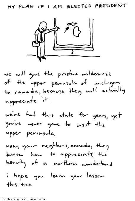
Within a year of living in Madison, Amanda and I had exhausted our two hiking guides of everything remotely interesting within 4 hours of a town that was, otherwise, a fantastic place to live. So we headed north to ‘the UP.[2]’ This was Amanda and my first backpacking trip together. It would take more for us to learn to do it together well. But this is Midwest hiking at its best. The first day was a spectacular coastal hike along the boundary waters of Lake Superior.

The second day jutted inland following the river and climbing a number of dramatic water falls.

The final day ended with views of Porcupine mountain, the highest point in the quad state region…at ~2,800 ft. Lets just say that Midwest hiking is not about elevation.

This, of course, sets up this brilliant comic by ‘Toothpaste for Dinner’:

#13 Avalanche Pass to Colden/Algonquin (1 to 3 days, 18 to 22 miles)

Adirondack Park is the largest state park in the lower 48. They are also my ‘home mountains.’[3] This is where I fell in love with the air, the burn, the views, the miles, the solitude, the adventure, and the wonder the unmitigated brunt of creation. As a kid we made occasional outings but it was not until college, when I went backpacking with the Geneseo outing club and led wilderness trips in the summer that they became very familiar. Western hikers chuckle when I talk about the 46 peaks between 4,000 and 5,200 feet that New Englanders ‘collect’…or the long wooded hikes that only grudgingly relinquish their views in the final 100m. But there is still something magical about them. The ‘Daks are over a billion years old (some of the oldest rocks in the lower 48) and are such a good example of anorthosite, that the rare metamorphic often takes their name.[4] There is no equivalent to crossing a stream lined with the enormous, dramatic clasts of metamorphosed feldspar that glint rainbow sheens through the shallow flows.[5]


I took the famous trail through avalanche pass. Avalanche pass follows Avalanche Lake between mount Colden and Mount Algonquin. The novel thing about this ‘pass’ is that there are places where the lake fills the entire span between the granite cliffs, requiring special constructed bridges built into the side of Algonquin.

(Note: I got this picture off the web...it is not from our trip.)

This was before I believed in tents[6] and was visited that night by a fox. The next day I went up the back side of Colden[7]. It seemed surprisingly difficult and I shook my head at how out of shape I was. When I reached the peak I was greeted with apparent surprise of a group of middle aged men. One of them was a guide who articulated their interest. “You came up the back side of Colden in full pack. That’s impressive, man.” It was a vindicating moment.

I have since learned the back sides of Colton and Algonquin are ‘affectionately’ nicknamed[8] “Three miles straight up.” A couple years later, Amanda and I did Algonquin (the second highest of the ‘Daks) back side trail, as a day hike, in knee deep snow. Let’s just say, she is not that happy with me in this picture. But it was still a fantastic day.[9]

#14 Notch Mountain: Rocky Mountains CO (1 day: 10 miles)

I had always suspected I wanted to live in the west…this was the day I knew it. I was in Denver on business and I stayed for the weekend, rented a car, and picked a couple mountains to climb. The fist night I went to a Colorado Rockies game before I headed out, so I arrived at the camp site in Vail after 11pm. It was full. So I drove the little rented Neon over the dark, washboard, dirt road for miles and napped in the car at the trail head. I was up and on the trail by 5. The first mile or so was familiar, a lovely wooded trail. But then something totally unfamiliar happened. I crossed the tree line near the beginning of the hike[10], giving me wide open views of vast alpine meadows and neighboring peaks for the vast majority of the hike.

I was the first one on the trail so I saw all the Marmots and Pikas (merely mythical creatures of 3rd grade science reports to that point) I could ever want to. The summit yielded a gorgeous view of the famous Mount of the Holy Cross.[11] It was a beautiful day.

The next day I climbed Mt Massive.[12] This was a much more challenging climb and I got altitude sickness (the only time I ever have) and badly burned. But these were minor costs. It was even more dramatic than Notch. I was hooked. We were eventually headed west.

Honorable mention:

Macomb Mountain – I climbed the slide of this un-trailed Adirondack Peak with the Geneseo outing club[13]. It was October and you could see Vermont and a sea of peak, north eastern, deciduous color. We climbed two more peaks that day and then got lost, spending the night[14] by a river and a huge bonfire.[15]

Dinosaur National Park – On our first vacation together ever, we took this short evening hike along the green river, with great Uinta monoliths in the background. The trip to Dinosaur was far more about fossils than hiking. But we mainly went because I wrote a 50 page paper in undergrad on the geomorphology of this part of the park. I literally labeled and described the geologic history of each stream (there must have been about 300) within several square miles of the place where Amanda stands in the picture. Ah, the scientific education.

Rocky Mountain National Park – This was our first excursion to western peaks (same trip as Dinosaur above). It was a vacation to celebrate finishing my Wisconsin Masters degree. We did not realize how late western peaks stay snowed over so our hikes were difficult. We climbed flat top mountain in the snow and Amanda got a second degree sunburn. But the surrounding peaks were unlike anything we had ever seen[16] and when we woke up one our tent was surrounded by elk. I’m sure I remember it as more fun than it was, but I remember it as really fun.


Olympic ridge – One day 18 mile loop into the heart of Olympic National Park with spectacular views of Mt Olympus. We slept at the trailhead and hiked hard, but the ridge yielded views of the central peak for several miles.

Dix Mountain – Amanda and I climbed this peak in the fog. There was no view. It is the only peak I have climbed twice by different routes.[17] But we had a great day together. What could otherwise be considered a sub-par day on the mountain is one of my favorite days I have spent with my wife.
Lake Louise/Lake Agnes – The Canadian Rockies are seriously underrated. Canadian trails are more like European trails in that they have periodic ‘tea houses’ where you can stop for a snack and some tea. In a 16 mile day hike we encountered two of them. I have mixed feelings on these. They are really nice for breaks, but mitigate the wilderness feel. Tea houses aside, however, the Canadian Rockies are 100% worth the trip. The only reason they did not crack the top 14 is because the trail guides tend to be unhelpful and I did not make good selections.
LeConte Mountain - Speaking of Wilderness architecture, we were invited to the wedding when a guy Amanda dated in high school was getting married just outside of the Smokey Mountains, shortly after we moved to Buffalo. I thought it sounded fun but also pitched a few hiking days as part of the trip. The highlight was climbing[18] LaConte Mountain. We found great views, but we also fund a cabin village and a lodge serving gourmet meals.

The Final pre-Kids trip in the West Sierra – 3 days, Gorgeous peaks, expansive lakes, a pace that covered ground but was healthy for marital harmony. Before I moved to CA this would have been 3 of the best days of my life. Now it makes honorable mention. That’s a good thing.


Point Rays ‘Manpacking’ – 3 days, 21 Miles. This was, actually, only a couple months ago. I started preaching at College Life, our church’s on campus college ministry. 8 guys planned[19] a spring break backpacking trip in Point Reyes national park.[20] Amanda gave me the green light and I had a blast getting to know the guys and hiking some of the most dramatic coastal trails in northern California.
This post was prepared while listening to A Beautiful Lie by 30 Seconds to Mars

___________________________
[1] As if this blog wasn’t topically eclectic enough.
[2] Michigan’s upper peninsula. One of the enjoyable subplots of living in the Midwest was meeting someone from Michigan and asking them where they lived. They would put up their right hand like a mitten, representing the southern land mass of their state…and point. This became particularly hilarious when they lived in the UP because representing the whole state left them without appendages to point, and they would sometimes involve their nose in an elaborate way of conveying precise information of limited value.
[3] Every hiker has ‘home’ mountains. And while the Sierra has long since surpassed the Adirondacks as the mountains I know the best and am most comfortable in, the ‘daks will always be where I learned the skills and made mistakes and got hooked.
[4] E.g. adirondak anorthosite
[5] In undergrad, the guys who had jobs in the geology thin section lab, would use the rock saws to make gifts (like book ends) out of finished blocks of anorthosite.
[6] I used to believe that you should save the weight of a tent by just bringing a small tarp and a bug net.
[7] Coldon is nestled between the ‘daks two highest peaks, Marcy and Algonquin. To date, it is my favorite view (apart from the October summit of Malcolm that had more to do with foliage than rock – see Honorable Mention). It reminds me of that shot in the Lord of The Rings where you can make out Isengard and the Great Eye of Mordor ominously dominating the landscape.
[8] By my friend Brian Chapman.
[9] My friend Brian and I have considered writing a book called something like, ‘How to Take Your New Wife Hiking.’ Almost every guy I have ever talked to who has tried to introduce their girlfriend/wife to their passion for peaks and miles, made the exact same mistakes of too much too early.
[10] Up to that point I had only experienced the ‘Daks, where the only view was at the very peak. This was like an enthusiastic recreational pot user suddenly shooting heroin into his eye balls.
[11] So named because the geologic formation that retains snow in perpendicular cracks well after it has melted elsewhere, leaving the stark mountainside emblazoned with a cross for much of the hiking season (though it was mostly faded by the time I got there).
[12] The second highest mountain in Colorado by like 14 ft…actually, before the USGS updated the datum a couple decades ago, it was considered the highest.
[13] When the guy in charge of lunch busted it out it consisted of a block of cheese, a hunk of salami, and a huge chocolate bar. This became my tradition...until the enobling influence of marriage.
[14] Again, this was Columbus day weekend, so it was literally freezing (our water bottles formed ice). But I was lost with another geophysicist and a geochemist. We had all TA’d intro geology. Topos were second nature and we did just fine. There was a funny moment from that night worth relating. After it was clear we were lost in the dark with limited flashlight time I said to the other two guys (who were pretty good friends) ‘You know guys, when I get in situations like this, I like to pray’ (suggesting I take a moment to do so – Ah, more passionate and annoying days). Dave the geochemist responded ‘Do you get in situations like this a lot?’ This was also the trip in which I became a pants convert. Up to this point I did not believe in pants…hiking only and always in shorts. Lets just say…I now believe in pants.
[15] Oddly, there were three pictures from this weekend in the Geneseo yearbook (one of the photographers was on the trip). I only know this because my Mom secretly bought one.
[16] Amanda commented that it was like someone was doing a CGI feed for our vacation.
[17] I climbed the slide with the outing club in undergrad.
[18] We did not originally intend to climb the mountain. I was just going to be an easy hike to a big waterfall. But it was Fall and the waterfall had dried up, so we missed it and kept going. It was a beautiful day and a great outing, so we just kept going and before we knew we had climbed the mountain.
[19] This is one of my favorite differences between college ministry and youth ministry. I literally just packed my stuff and showed up. They had planned everything.
[20] A peninsula on the pacific coast literally formed by the San Andreas fault shearing part of California off into the ocean.